Originally posted by Denny
View Post
-
They aren't letting people into the park until AT LEAST July 6th. They lost Memorial Day and they are going to lose Independence Day.Leave a comment:
-
Oasis parking lot at joe pool lake. About twice as high compared to a few weeks ago. I'm guessing oasis is going to be losing a lot of money for a while


Leave a comment:
-
South side of Hubbard is getting flooded pretty badly from opening the dam.Leave a comment:
-
Have you seen the creek/ river that runs thru george bush. Over flooded.Leave a comment:
-
Can't remember where I read it but the Corps is talking to Wylie PD about shutting down Hwy 78. They want to open the flood gates all the way.Leave a comment:
-
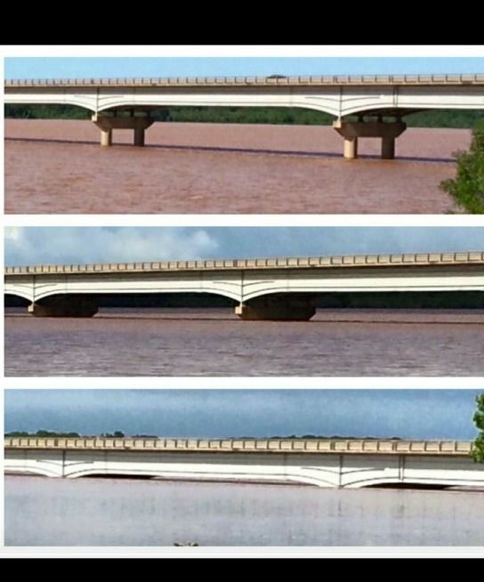
I live just south of the Willis bridge on 377. I stopped to see if the water was at the bottom of the arches this morning. It still had a couple inches left, I expect the gaps are gone now. The 2 southern most archs are a couple feet higher than all the rest of the bridge. This bottom clip was from earlier in the week, I could just barely see a gap this morning
Usually there's amost a 30 foot gap, the top portion does not even reflect normal
Leave a comment:
-
Yeah its completely overrun by at least 10 ft.Originally posted by Big A View Post
Pleasant Valley has barricades up at the base of the residential development to the west with water visible at the fence level of those houses.
I didn't try to come down from 190 so don't know how far out it ran.
I know its been there for a long time, but i have never seen the water that high. I dunno if it will return or if the owners will take the insurance money and run.Leave a comment:
-
Rowlett Creek, which flows in to the lower west arm of Ray Hubbard is 20+ feel over the banks and over 600 ft wide shore to shore the lake all the way north into Wylie.Leave a comment:


Leave a comment: